Bartolome Island

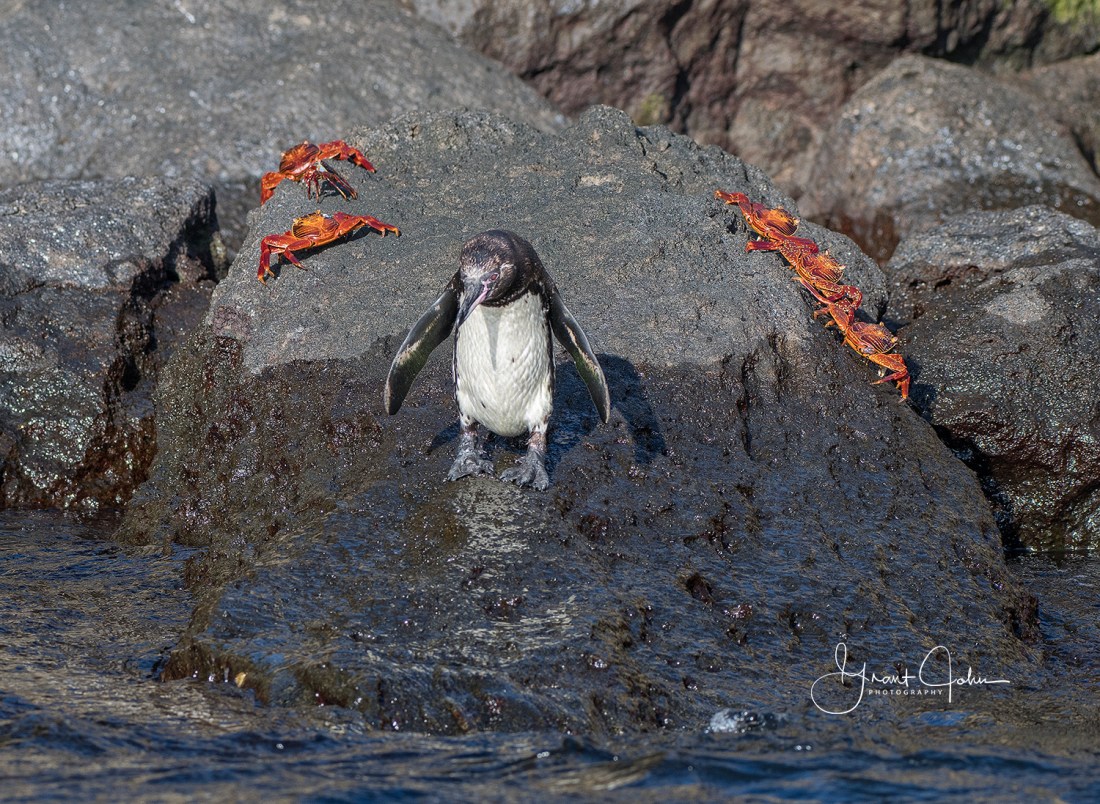
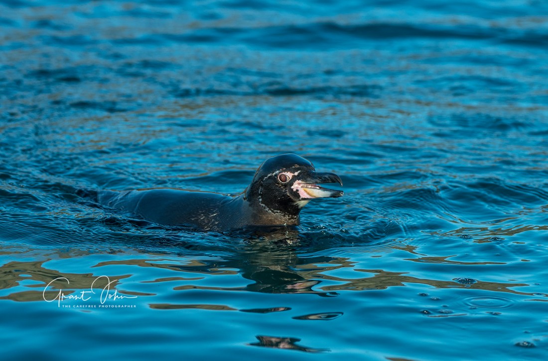
Next up – Batolome! This is a smaller volcanic cone east of the larger Santiago Island. The cone is easy to climb and the views are outstanding. The island is famous for its’ Pinnacle Rock, the distinctive characteristic of Bartolome, and the most representative landmark of the Galapagos. Our hikers went ashore to climb to the top of the island – 370′ – for a wonderful volcanic view of the whole island and Pinnacle Rock. The rest enjoyed a panga ride, a beach landing and later snorkeling in rather rough seas. The latter adventure – done by few – was rewarding for an experience watching a group of penguins swimming around and under the panga.

Views and People

Wildlife

Penguins

DSC_3069DSC_3076DSC_3085DSC_3185DSC_3221DSC_3318DSC_3336DSC_3350DSC_3359

Isabela Island

Our first overnight stop in the Galapagos was Isabela Isand. We enjoyed several activities on or around several spots on Isabela over a two day period.

PUNTA VICENTE ROCA

This point is located at the mouth of the head of this sea horse shaped island. The rich up-welling of the Cromwell Current provides all the necessary nutrients for abundant marine life. The entire area of Punta Vicente Roca lies on the flank of the 2600′ volcano Ecuador; half of this volcano has slid into the ocean, leaving a spectacular cutaway view of its’ huge caldera.

Our activity here was a panga ride along the cliffs of the point. Although the seas were a little rough, we were delighted to see flightless cormorants, sea lions, seals, marine iguanas, pelicans brown noddy terns, Galapagos shear waters, petrels and Galapagos penguins.


URBINA BAY

The next day we made a wet landing on Isabela at Urbina Bay. This bay is located at the base of Alcedo volcano on the west coast of the island. The area experienced a major uplift in 1954, causing the land to rise over 16′. The coast expanded half a mile out, leaving marine life stranded on the new shore.

We landed on a black and somewhat rocky beach, and walked about half a mile into a forested area along a strictly controlled footpath. On the walk we encountered numerous Galapagos giant tortoises and land iguanas, as well as hawks, finches, mockingbirds and warblers. We also learned that up until the early 2000’s there were many goats in this area, which have subsequently been eliminated because of their adverse effect on the foliage and thus the natural inhabitants.

Tortoises

Land Iguanas

Finches

Mockingbirds/Warbler

Carpenter Bee

Floral


TAGUS COVE

Tagus Cove, named for a British naval vessel that moored here in 1814, was used historically as an anchorage for pirates and whalers. One can still find the names of their ships carved into the rock. The cove is approached through the Bolivar Channel.

Some in our group landed, and hiked about a mile uphill, mainly to enjoy a wonderful volcanic view and Darwin’s lake. Others chose a panga ride along the cliffs and the tuff cone formations. These provide a wonderful shelter for many boobies, penguins, brown noddy terns, sea turtles and sometimes whales and dolphins.

We also had an opportunity to snorkel in this same area. A special treat was an encounter with a sea horse (unfortunately we have three short videos but no still images).

Galapagos Island Paradise

The Islands

The Galapagos Islands are a volcanic archipelago straddling the equator in the Pacific Ocean. Situated about 600 miles off the coast of Ecuador, the islands – a province of Ecuador –  are one of the world’s foremost destinations for wildlife viewing. The islands offer a broad diversity of plant and animal species, many found nowhere else. Charles Darwin visited the Galapagos on the HMS Beagle in 1835; his observations later inspired his theory of evolution. The islands also provided a base for whalers and pirates. The former nearly wiped out the tortoise population in the 1800’s, taking them on-ship as a lasting source of protein. The first recorded visit to the Galapagos was that of the Bishop of Panama, who accidentally discovered them on his way to Peru in 1535.

The chain consists of 18 main islands, 3 smaller and 107 rocks and islets. Isabela, shaped like a seahorse, is by far the largest at about 2000 square miles, 75% of the total land mass of the Galapagos. Named after Queen Isabela, the island has six volcanoes,  rises to 5600′ and is bisected by the equator. The youngest and adjacent island of Fernandina (named after King Ferdinand) has extensive lava fields, home to many interesting species The distance from south to north (Espanola to Darwin Island) is 137 miles. Four islands are inhabited, with a total population of about 25,000 people; only 3% of the total land mass is inhabited.

The geology of the islands is relatively young. There are numerous contemporaneous volcanoes , some with eruptions as recently as this year. The westernmost islands and their volcanoes are youngest, and are taller with well developed calderas.

Darwin visited four islands over a period of six weeks. He spent a considerable part of this visit studying volcanic activity and structures. He also noted that the mockingbirds were different island to island, and he collected dozens of birds to take back to England. He noted post trip that, while different and unique to each island, most of the birds were finches. This discovery started the development of his thought process on evolution.

Ecotourism in the Galapagos has grown substantially over recent years, with about 220,000 visitors in the latest year. 97% of the archipelago is a National Park, and ten islands are accessible only by sea. Ecuador has permitted these visits despite very strict conservation policies. Visitor sites are very limited, with only 54 permitted land sites and 62 scuba/snorkeling sites. Landings are limited to 20-25 people at a time, and the allowed walking areas are tightly controlled. While there are multiple tourist ships visiting each island at one time, these are typically smaller cruise vessels with 10-100 passengers only. Each vessel is limited at any given site to once per two weeks.

Our Visit

Typically the duration of a  Galapagos cruise is one week, Saturday to Saturday.  Our group of ten flew from Quito to the small island of Baltra (an old US Air force base), adjacent to the larger island of Santa Cruz. We were transported by bus to an ocean-side landing area, boarded on pangas (inflatable dinghies or zodiacs) and transported to our home for the next week. This was the Evolution, a 32 passenger cruise ship, really a motor yacht, owned by Quasar Expeditions and operated for our visit by International Expeditions. The spacious cabins (140 to 260 square feet) are situated on three different levels, with the lounge, office and dining ares between. The ship, refurbished in 2017,  has a length of 192′ and a beam of 29′. It is operated with a crew of 18, plus two well trained Ecuadorian naturalists. Our guides, Cris and Bolivar, were outstanding – and lovely people to boot.

The yacht is comfortable, the crew like family, the food wonderful and the activities delightful. A typical day consisted of at lease one island landing,  snorkeling from the panga (followed by a hot tub visit!) and a panga ride along the shoreline to view birds, penguins, sea lions and the like. Three lovely and delicious meals, ample beverages and a highly informative lecture were included.

Our cruise was designated as the Darwin route, from Baltra past Daphne Major to Isabela and Fernandina, back to Bartolome, to Santa Cruz and Rabida Islands, a stop at Puerto Ayora on Santa Cruz  to visit the Darwin Research Station and to see giant tortoises in the cloud forest, on to Espanola and finally to San Cristobal. We flew from there back to Quito after an absolutely wonderful experience.

IMG_5257

A Trip to Otavalo

Our second day in Quito, we journeyed about two hours north to Otavalo in Imbabura province. Our goal was the native craft market in that town. The bus route takes the Pan-American Highway, and along the way we passed many plastic sheeted greenhouses where roses and other flowers are raised. Cut flowers – particularly roses – are Ecuador’s third major export, after Oil and bananas.

Our first stop was at Quitsato, some 47 KM northwest of Quito and near the town of Cayamba. The point of interest here was a monument of sorts to the equator consisting of a 52 meter diameter paved circle with a line representing the equator across its’ center.Interestingly there has been an archaeological center for thousands of years, with constructions recognizing the center of the earth straddling the equator line; the people apparently recognized long ago that the earth was round. They used the presence of large land masses (volcanoes) to position these constructions. This present-day site is advertised as the ideal point to stand in both hemispheres at the same time, as most other sites are quite inaccessible (oceans, rain forests, etc.)

We than stopped at an overlook called Miralago with views of a lake (Lago San Pablo) and a volcano system with three peaks (Imbabura). Coffee, snacks and shopping added to the views, and we boarded two young native girls selling hand woven scarves.


Next stop was the town of Otavalo, a fairly good sized place well known for its’ market. The town is located in Imbabura province and is surrounded by volcanoes including the three peaks of Imbabura. The market is situated in Plaza de Ponchos, and is populated by traditionally clad indigenous town people selling textiles and other handicrafts. It is a good size, and has much to offer. We left the market to visit a local industrious household with several looms, busily manufacturing scarves, purses and other goods.


Our last stop was at Hacienda Pinsaqui, a local hostelry and restaurant just outside Otavalo. This is a 1790’s vintage colonial house, with tile floors, sheepskin rugs, whitewashed walls and lots of period furniture. The latter was all hauled by mules from the seafront. Simon Bolivar apparently used to stay here. We were treated to a very nice Ecuadorian lunch before our long trip back to Quito.

Museo Casa del Alabado

Quito has a wonderful little museum in the old town, opened four years ago, that has a fairly large collection of pre-Colombian art. Containing about 5000 pieces, the museum is made up of archaeological items from most of the cultures which formerly inhabited all regions of what is now Ecuador. The museum is housed in a restored mansion built originally in 1671.

The collection is organized thematically, with a focus on native ancestral ritualism and spirituality in the Americas. The pieces date from 7000 BC through the arrival of the Spaniards in 1530 AD. The ancient cultures inhabited the Pacific Coast all the way to the tropical forests and mountains of the Andes. The artifacts in the collection include creations in pottery, stone, conch, metal, textiles and wood. They show an incredible range of technical skills and a significant diversity of styles and shapes.

The history of the region began at the end of the first ice age. The pre-ceramic period, which ended around 4200 BC, consisted of the Las Vegas culture, who were hunter-gatherers and fishermen on the coast, and the Inga culture located near present-day Quito. The Formative period began and flourished with farming and the use of ceramics. The major culture then was that of the Valdivia, the first culture where significant remains have been found, dating as early as 3500 BC.

This period was followed by the development of more stable cultures located in discrete towns, focused more on farming , trading and other activities all the way through to the 15th century. The Incans invaded the area from Peru in the late 1400’s, but only controlled Ecuador until the arrival of the Spaniards.

The museum is well organized, and with an accomplished guide can be reviewed in an hour or so. The open courtyard includes comfortable seating and offers limited refreshments.

Ecuador and the Galapagos Islands

We recently returned from a ten day sojourn to Quito, Ecuador and the Galapagos Islands, and what a spectacular trip it was! I will be doing a number of blog posts covering this visit, starting with our brief time in the capital city of Quito. We have literally hundreds of photos to share, particularly of the wildlife on the islands. But first Quito.

The capital city of Ecuador is located at 9350′ elevation in a valley adjacent to an active volcano, Pichincha, and in the Andean foothills. The population is about 3 million people. It was the first city recognized by Unesco as an historic site. Constructed on the foundation of an ancient Incan city, Quito is known for its’ well preserved colonial center, rich in 16th and 17th century churches. Quito is a blend of European, Moorish and indigenous styles. Highlights include the cathedral, the Plaza Grande square and the ultra-ornate Compania de Jesus Jesuit church.

First populated some 8000 years ago, the city was established in 1541 and named San Francisco of Quito. There are more than 200 churches, convents and monasteries in the old town, and many cases of original buildings exist. The old city is charming, with many sights and restaurants, and very friendly people.

Ohio Pass Road

Ohio Pass road is probably the prettiest route from Crested Butte to Gunnison, although certainly not the fastest. The views are spectacular in wildflower season and in the fall when the aspens are turning. The route is 22.5 miles long and runs over Ohio Pass at a peak of 10,076′. About 1/3 to 1/2 the road is gravel, but passable for regular vehicles.

To take this route, head out of Crested Butte along Kebler Pass Road for about 7 miles. Watch for a left turn onto CR 730, or Ohio Pass Road. The peak is reached about two miles later. Parts of the road which flank Mt. Axell are gravel, narrow and shelf-like.

Views of the West Elk Mountains and eventually The Castles are quite rewarding. And the road passes through a substantial forest of aspens which is stunning in the fall. Eventually the road descends to the old town of Baldwin, established in 1881 during the gold rush. The focus ended up on coal in this area. The road, now paved, runs about 15 miles through the Ohio Creek valley by farms and ranches.

San Juan Mountains

In southwest Colorado, the San Juan Mountains offer perhaps the state’s most varied scenery with 13 peaks over 14000′.  The mountains contain highly mineralized veins of silver, gold, zinc and other metals. The towns in the area are all unique and interesting, many established during the mineral rush in the late 1880’s. They include Silverton, Ridgeway, Ouray and Telluride. The San Juans were the home of the Ute Indians for hundreds of years.

Today this area is  very active year around for hiking, skiing, off roading, camping and other activities. It is also a photographer’s paradise, particularly during the fall color change. The area between Ridgeway and Telluride provides expansive views of the “Sneffels Range”, which includes the Uncompahgre National Forest (950,000 acres), Mt. Sneffels, Dallas Peak, Mears Peak, Wilson Mesa and Mt. Wilson.

Take SR 62 west from Ridgeway towards Placerville and Telluride. About 8 miles west of Ridgeway one comes to a parking lot in an area called Dallas Divide. This location offers one of Colorado’s iconic photography spots (others include Maroon Bells and Crystal Mill). This offers a view of the Sneffels Range along with massive aspen groves and other rolling land and forests.

Beyond this stop, one can take Last Dollar Road (CR58P) over to Telluride. This road is a winding, narrow trek of some 21 miles, and offers spectacular views including Wilson Peak. A 4WD vehicle, while not necessary, is strongly recommended.

Back towards Ridgeway, there are two county roads which run through the Double RL ranch (read Ralph Lauren) into the Uncompahgre National Forest. These are both fairly smooth gravel roads – windy and somewhat narrow but passable for passenger vehicles – which both offer more spectacular views of the range and massive groves of aspens. One is CR 9, or West Dallas Creek Road; the other is CR 7, or Dallas Creek Road. Both follow the Dallas Creek valley for 6-8 miles up into the foothills, and are commonly used for hiking access to the forest.

Kebler Pass Road

Gunnison County Road 12, commonly known as Kebler Pass, runs between SR 133 between Paonia State Park and Crested Butte. This is a gravel road, closed in the winter, but passable by passenger car otherwise – as long as it is not really wet. Then one might be better in 4WD. The summit is neared Crested Butte at 10000′, and the road is about 33 miles in length and takes at lease two hours to traverse.

Why travel along Kebler Pass road? There are many areas for camping, hiking and biking, and  includes a couple of beautiful mountain lakes called Lake Irwin and Lost Lake. The road is part of the West Elk Loop, which runs for 205 miles starting in Carbondale along SR 133 and winding through Crested Butte, Gunnison, Poania and several other towns.

The views of the West Elk Mountains, Ruby Ridge, Marcellina Mountain, West and East Beckwith Peaks and Gunnison National Forest are spectacular. This is especially true in late September and early October when the aspens are turning color from green to yellow and sometimes to oranges and reds.

Interestingly Aspens have a single root system, are a clonal colony and are a true single living organism. Some believe that the areas along Kebler Pass road form the largest aspen forest in the US. During our travels this recent fall, we felt that the single most spectacular area was along Kebler Pass. Plan your next visit to Colorado for this season and you will not be disappointed.

Castle Creek Road

Just outside the west side of Aspen, one can take a 13 mile paved road to the ghost town of Ashcroft. The road runs along the Castle Creek valley, and is surrounded by expansive forests of aspens which provide a rainbow of colors across the valley. It is indeed an awe-inspiring drive.

Ashcroft was established in 1880 during the silver boom in Colorado. At one point the town had more than 2000 residents. The old buildings are very photogenic and cap off a beautiful drive.

If one continues for a few miles beyond the ghost town, the views of the valley and Castle Peak at 14000′ are wonderful. For the 4WD fanatics there are two rough roads continuing up into the mountains. Very little opportunity exist to torn around or to pass other vehicles, so be cautious.