West Coast of Vancouver Island

If you have never visited the west coast of Vancouver Island, you have really been missing something. The drive from Nanaimo on the east coast is 2 – 2 1/2 hours through gorgeous mountainous terrain past a number of large lakes. Before reaching Port Alberni, you will come upon a magical place along the road. Cathedral Grove, located in MacMillan Provincial Park, is one of the most accessible strands of giant Douglas fir trees on Vancouver Island. Here one can stroll through a network of trails under the shadow of towering Douglas fir trees, some more than 800 years old.The grove was a well known tourist stop on Alberni Road in the 1920’s. In 1944 the area was donated by H.R. MacMillan for the perpetual enjoyment of the public in recognition of he unique stand of trees. The grove became a provincial park in three years later. Natural regeneration is beginning to restore the Grove’s pristine beauty. This provide a unique opportunity to experience the diversity of plant like typical in a very old forest.

Once through the town of Port Alberni, the road takes a route to the west along Sproat Lake and along some impressive peaks.  Eventually the road runs down steep, winding hill and then along Kennedy Lake. Past that, the trail ends at the Pacific Run Highway, the principal road along the west coast. To the right, Tofino. To the left, Ucluelet. In between, Long Beach which stretches for 10 miles along the Pacific and offers wind swept sand, big surf and washed up kelp. Our main point of interest was Ucluelet (means safe harbor), a town of 1800 people situated at the edge of Barclay Sound framed on three sides by the Pacific Ocean. The Pacific Rim National Park with huge stands of cedar, fir and hemlock is nearby. Visitors come to Ucluelet to surf, hike the Wild Pacific Trail, fish on the big bank, whale and bear watch and relax on the beach. In fall interests turn to storm watching.

We are here to fish, at least principally. This is a well known fishing spot for salmon and for halibut. But when not fishing, the area is unique, and the stormy seas, foggy conditions and black rocks along the shore are a fascinating subject for photography and for viewing. And there are fine places to stay and to dine, some upscale, some more casual. Our favorites included trailer food at Raven Lady – fresh BC oysters on the half shell, tuna poke, salmon burgers, fish tacos and po’boys, all situated with nearby tables right next to a BC liquor store! On the upscale end, dinner at Norwood’s was magnificent. The restaurant is in a smallish house with an open kitchen and maybe 20-25 seats. The halibut was superb, as were the fresh mussels and octopus. And the wine list is filled with impressive BC wines.

There are some lovely places to stay, especially Black Rock Resort, situated right against the roaring surf on the Pacific side. But we found great condos at Whiskey Point – overlooking the harbor, adjacent to the aquarium and a short walk to Zoe’s bakery. There are many choices for fishing guides, and the rush out of the small boat harbor at 6 am was quite exciting. Partial day charters typically run around the peninsula and up a few miles to Wye’s Point; these are normally focused on salmon. Full days can go south to the so-called Big Bank and fish for halibut.

Off days can be spent exploring Long Beach, the lighthouse, and Tofino. This is a more bustling touristy town of maybe 2000 permanent residents, situated at the north end of the peninsula some 20 miles from Ucluelet. Many of the same activities can be enjoyed around Tofino, and there are more choices of condos, resorts and restaurants. If you want busy, go to Tofino. One spectacular place to stay, to dine or to ocean watch is the Wickaninnish Inn, located just a few miles south of Tofino. This is also the center of strom watching in the off season.


Vancouver Island offers many other great places to visit. We have covered Victoria and the West Coast so far. In a future blog we will relate experiences on the east coast from Parksville to Campbell River, and provide some thoughts on a two day sail in the Gulf Islands.

A Weekend in Victoria

We recently spent a two-day weekend in Victoria, BC. Arriving by Coho Black Ball ferry from Port Angeles, WA , we checked into our hotel, The Hilton Doubletree on a Friday evening and quickly settled in to our two bedroom suite. The hotel sits right behind the grand dowager of Victoria hotels, the Empress, and we had magnificent views of the Inner Harbor, the Parliament buildings and the immediate downtown area. While there are many other choices in the downtown area, both these hotels are lovely and well situated.

Since we only had two full days in the city, we decided to focus on three activities. First we visited a very well done Royal BC Museum. Regular exhibits provide a focus on the natural and human history of the northwest part of Canada. Obviously there is a large exhibit devoted to the First Nations people and culture, complete with a totem hall, masks and other regalia. Outside the museum building there is a native house called Wawadit’la, or Mungo Martin House, complete with several totems, and also a garden devoted to native plants. We were also keenly interested in a current exhibit on Egypt: The Time of Pharoahs, accompanied with a good IMAX movie on the same theme.

Second, we enjoyed several blocks of downtown Victoria especially along Government and Wharf Streets. This is a very lively area replete with restaurants and specialty shops with views overlooking the harbor and marina. We especially enjoyed the people activities from walkers to visitors to cyclists to street performers. This was true during the day and evenings both. Our favorite dining establishments were the Steamship Grill and Bar on Belleville on the harbor, and Il Terrazzo  on Johnson Street. Seafood of course! We developed a real love for BC oysters. Following dinner at Il Terrazzo, we could not resist an after dinner drink at the Empress – what elegance!

Third – and a must – is a visit to The Butchart Gardens near the city. These gardens,  known world-wide,  cover more than 55 acres of a 130 acre estate and began with an idea that Jennie Butchart had to beautify the worked-out limestone quarry which had supplied her husband’s nearby cement plant. These gardens gradually expanded over some years to become the Sunken, Japanese, Rose, Italian and Mediterranean garden seen today. The gardens today are a National Historic Site of Canada, are visited by more than one million people each year.

Shooting the Milky Way

I recently attended a photography workshop in Big Bend country. Specifically we met at Study Butte, right next door to Terlingua, TX. The dates for the workshop were selected to a period with the darkest skies, typically the time coinciding with a new moon. In mid-August, moonrise and moonset do not interfere with the rise of the Milky Way.

_DSC5215

So some friends have asked “how do you take pictures of the Milky Way?” The first requirement is to find a place with very dark skies with minimal to no light pollution from anywhere.  So the Big Bend area is considered one of the best, if not the best, areas in Texas to get very dark skies. In fact some sources have rated it as one of the five darkest spots in the US. Then the question is when to go to Big Bend. Our workshop leader selected mid-August, since the moon cycle was favorable and the Milky Way arises about 10 pm, and is alive for several hours. In the spring you will be up most of the night!

The next requirement is to find a place with an interesting foregound. Ideally the foreground supplies interest and perspective to the image. Our choices in Big Bend National Park included Castolon (buildings and old industrial equipment) and Sam Nail Ranch (old windmills, walls and sotol plants). At the right time the entrance to Santa Elena Canyon would work well, or Casa Grande at The Basin, or Balanced Rock. In Terlingua the Milky Way is often photographed at the cemetery in Ghost Town with crosses or monuments as a foreground. Old churches or ghost town buildings can work too.

What about the camera and lens? Ideally one needs an DSLR with manual settings, time expose capability and a wide range of settings. The lens should be as wide as possible and as fast as possible. A fixed lens in the 14-24 mm range would be best, especially with an f-stop of 2.8 or less. And one also needs a tripod.

Okay, we are in place with the appropriate equipment and at the right time. What about camera settings? Well, I took these images with a Nikon D850 and a 16-35 mm lens set at 16 mm. All were shot as RAW images. Most were taken with the camera in the vertical position, set on manual, focus at infinity (or just about), shutter in mirror lockup position and a remote shutter release attached to my camera. I had good results with 20 and 25 second exposures at f 4.0 (wide open for this lens) and ISO set at 6400. The noise at this ISO level with a Nikon is manageable. Others in the group had f 2.8 lenses and were able to shoot a little faster with a lower ISO setting, which reduces noise and star movement. The latter becomes quite noticeable at shutter speeds above 25 seconds. One individual had an f 1.8 lens and was able to capture beautiful images at 15 seconds and an ISO below 2000. Take test shots to check composition and exposure, and use your histogram to set the latter.


What about post-processing? I normally use Adobe Camera Raw, but Lightroom works well too. Some processing is also usually done in Photoshop. I normally first adjust white and black sliders to idealize the histogram. Then I adjust highlights and shadows to satisfy my eye. Typically I will add 10-20% to clarity, 10-15% to vibrance and 5-10% to saturation. After I open the image I will also denoise, dehaze, sharpen and resize. Trial and error with lead your way to outstanding Milky Way pictures. Good shooting!

Ancient Italy and Vesuvius

A very important historical site is the located southeast of Naples and encompasses Mount Vesuvius and surrounding areas. Vesuvius, an active volcano, was 4200′ in elevation as of 2013, with a large crater 1000′ deep and 2000′ across; this formed after the last eruption in 1944. The area within 20 miles is home to 2 million people.

Vesuvius was dormant for centuries before the great eruption of 79 AD which buried Pompeii, Oplantis and Stabiae under ashes, and Herculaneum under mud. There have been a large number of eruptions since that time, with the most severe in 512 and 1632 (killed 3000 people). Activity has been substantial from 1660 to 1944.

Pliny the Younger witnessed the eruption in 70 AD from Naples, and described it eloquently in written accounts to Tacitus. He likened the eruption as a growing pine tree sprouting branches as it rose. His father was actually killed trying to rescue people at Pompeii. The city had 10-20000 people living in it at the time; about 2000 were killed. Pompeii was first mentioned in written texts about 310 BC; by Roman times it had become an important seaport, and a vacation spot for Romans. The eruption buried Pompeii and other sites under 20′ of ash, pumice and volcanic material. Pompeii, along with Stabiae and Herculaneum, were declared a Unesco World Heritage site in 1997.

Pompeii was discovered late in the 16th century, Herculaneum in 1709. Excavations began in Pompeii in 1748, and are still ongoing. The city is remarkedly well preserved (except for wood and similar materials). A significant=cant number of skeletal remains have been “preserved” as plaster castings, and many artifacts were also recovered. Most of these have been relocated to the National Archaeological Museum in Naples. The walls are about 2 miles in circumference, enclosing 163 acres. There are seven city gates, and three primary thoroughfares. The Forum was the center of religious, economic and municipal life, and encompasses temples, wool headquarters, meeting places for council and magistrates, a basilica a sports ground, theaters and baths. There are hundreds of houses, some luxury versions taking up a whole city block. Shops abound, and include bakeries, wool processing, gem cutting, baths, ceramics, toolmakers, foods, wines, lamps, fish sauce and so on. The excavations have unearthed a great historical site which has been extremely valuable for studying the culture and life of those times.


Herculaneum was also buried, but under a mass of tufaceous material 50-60′ deep. There were very few fatalities; evidently most inhabitants had time to escape. The low humidity of the materials has preserved wooden frameworks of houses, furniture, a boat, cloth fragments and even some food. There are many houses and shops in the ruins, along with public monuments including a sports ground, a swimming pool and baths.

Both ruins continue to be excavated and studied. Pompeii and Herculaneum are fascinating to visit, and should not be missed if you are in this part of Italy. The tours are generally well done, but one can wander as well. Allow a full morning for Pompeii, and 2 hours or so for Herculaneum. And check out Cantina del Vesuvio for a wine tasting and light lunch in between.

_DSC4611

Ancient Ruins in Jordan

On a recent trip to Israel, we spent two days in the country of Jordan. While we initiated our visit with a visit to Mt. Nebo, we were particularly interested in two ancient ruins which date back at least two thousand years. One, Petra, is very well known as it now is commonly interested in current listings of Seven Wonders of the Ancient World. Nevertheless we felt the visit should be described in our blog as we were so impressed and awed at this site. The other, Jerash,  is somewhat less widely known but perhaps almost equally impressive. Let me start with Jerash.

JERASH

This is one of the best preserved and most original Roman cities in the Middle East. Located about 50 miles north of Amman, Jerash became an urban center during the Hellenistic period of the 3rd century BC. From the 1st century it drew considerable prestige for its’ status within the Roman province of Syria.It prospered greatly from its’ position on the incense and spice trade route from Arabia to Syria and the Mediterranean. By AD 130 Jerash was at its’ zenith, and flourished both economically and socially. After a decline it flourished again under the Byzantines, notably in the earl sixth century.

Entrance to the city is through Hadrian’s Arch. Alongside is the Hippodrome, where reenactments of the chariot races take place regularly. A notable feature of the city is the Oval Plaza, a unique monument from the Roman world. The plaza is 80 by 90 meters, enclosed by 160 ionic columns.

Untitled_Panorama5small


Beyond the plaza is the Cardo, a spectacular paved street about 600 meters long, lined with the city’s major buildings, shops and residences. Chariot tracks are visible in the stones.

_DSC4057_DSC4054_DSC4049

Additional ruins include the 2nd century Nymphaeum, a lavish public fountain, the Temple of Artemis, several Byzantine churches, the Baths and the North Theater.

While we were there, we noticed fairly large crowds of schoolgirls who were presumably on a special visit to learn. They were very happy and crowded around us, wanting to speak English. They shouted “hello, Hi”.

Jerash is well worth the trip from Amman, and one should allow at least half a day for a thorough tour. It is one of the best preserved Roman cities in the world.


PETRA

It is not known precisely when Petra was built, but the city began to prosper as the capital of the Nabataean Empire from the 1st century BC, which grew rich through trade in frankincense, myrrh and spices. Petra was later annexed to the Roman Empire and continued to thrive until a large earthquake in 363 AD destroyed much of the city. The earthquake combined with changes in trade routes eventually led to the downfall of the city, which was ultimately abandoned.

In 1812 a Swiss explorer named Johannes Burckhardt set out to “rediscover” Petra, and convinced his Bedouin guide to take him to the lost city. Petra since has become increasingly known as a fascinating and beautiful ancient city. Petra is also known as the rose-red city, taken from the wonderful and striking colors of the rock from which many of the city’s structures were carved. The Nabataeans buried their dead in intricate tombs that were cut out of the mountain sides, and the city also had temples, a theater, colonnaded streets and churches. Human settlement and land use for over 10,000 years can be traced in Petra.

After a 3-4 hour drive south of Amman, one starts a tour of Petra in the visitor center. The gateway to Petra is known as The Siq, a narrow gorge which resulted from a natural splitting of the mountain; it is 1.2 km long, and quite narrow in places. Water channels run along both rock faces. The Siq also holds many relics from Petra’s past, including a paved road and sacred stones.

The Siq opens up onto Petra’s most magnificent facade – the Treasury. It is almost 40 meters high, and intricately decorated with Corinthian capitals, friezes, figures and more. It is crowned by a funerary urn. The Treasury was probably constructed in the 1st century BC. The Street of Facades is the name given to the row of monumental Nabataean tombs carved in the southern face that lies past the Treasury.

IMG_2683

Next one arrives at a place of worship on a mountain plateau called The High Place of Sacrifice, reached by climbing rock-cut steps to the top. This was used for important religious ceremonies. The views are spectacular.

_DSC4140

Carved into the side of the mountain at the foot of the High Place of Sacrifice is a theater consisting of three rows of seats separated by passageways, all carved into the rock. Seven stairways ascend the auditorium and it can accommodate 4000 spectators.

Untitled_Panorama3small_DSC4117

Beyond the theater are a series of Royal Tombs, a Nymphaeum or public fountain, The Church, the  Great Temple and the Monastery. The whole city stretches more than 2 km from the exit from the Siq. All this was carved from the mountain.

Petra has numerous hiking trails in and around the ruins, ranging from 3 km to 10 km in length and of varying difficulties.  While one can get a real flavor of Petra in a day, one could spend several days here hiking and exploring. While most people walk into Petra from the visitor center – a hike of 2 km –  there are horses and horse drawn carriages that will provide rides to the Treasury.  Camel and donkey rides are also available within the city from the Treasury up to the Monastery.

Adventures in Alaska

Two years ago, we took a break from our African visits to go to Alaska for a couple of weeks. Of course we did most of the usual stuff (except cruising on a large ship). We started in Anchorage – lovely city, good restaurants (try Simon and Seafort’s – the halibut cheeks were wonderful), a very well done Anchorage Museum (land, people, art and history of Alaska) , and interesting activity around a busy Lake Hood seaplane base. Then we headed to Denali National Park on the train, a three day journey up, into, and back. This was well worth the time, and something one just has to do. The scenery was awesome, we did see some wildlife (a grizzly, some Dahl sheep, some caribou and a  moose in town). But we did not see the peak; apparently 70% of the visitors do not because of cloudy skies. http://www.simonandseaforts.com. http://www.anchoragemuseum.org.

We then drove down the Kenai Peninsula to Homer, and spent three days there. Neat little town with great views of Cook Inlet and the mountains on the afar Katmai Peninsula. Lots of local restaurants and shops, and the famous Homer Spit with its’ equally famous Salty Dawg Saloon. We fished for halibut – caught our limit and later thoroughly enjoyed the eating – a good time, but it was like pulling a dead weight up 100′!TGJ201507120596

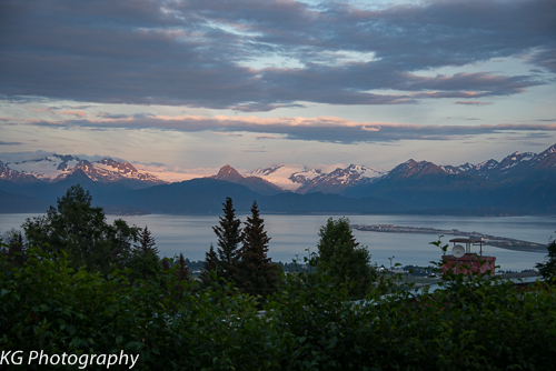
Then off to Sitka and an eight day cruise in the Inner Passage, ending in Ketchikan. Wonderful experience to spend that time on a 40 passenger catamaran (with 17 crew) cruising the waters of the Inner Passage.

We had several really neat adventures that I want to tell you about in some detail.

Alaskan Dream

The first is the cruise itself. A small boat cruise like this is very special. We made 36 other friends, and loved the crew from the captain to the chef to the pastry chef to the naturalist to the deck hands. The food was fabulous. The cabins were small but comfortable – all we did there was sleep. The sights were unbelievable. The activities and lectures were both educational and enjoyable. This cruise is an intimate exposure to some of our most beautiful geographic sights, fascinating cultures and wildlife. http://www.alaskandream.com. Some highlights:

  • Sitka is a really interesting town, established in 1799 by the Russians and it functioned as the capital until the US purchase. Highlights include St. Michael’s Russian Orthodox Cathedral, the Naa Kahidi Tlingit dancers at their community house, the Russian Bishop’s House built in 1842, the Sheldon Jackson Museum (Alaskan native ethnographic material), and a harbor cruise (seals, whales and lots of fun to watch sea otters)
  • Icy Straits and Glacier Bay are both spectacular, especially the Marjorie Glacier at the far end. We took an inflatable boat ride (DIB) and walked around Reid Glacier, a neat experience.
  • The best of Juneau – a lovely seabound city – was the Mendenhall Glacier. We also enjoyed a wonderful Alaskan outdoor evening eating salmon and crab at the Orca Point Lodge.
  • Cruising up Tracy Arm is  great experience – 400′ cliffs, waterfalls galore, glaciers and a DIB ride among the bergs and close up to the main face.
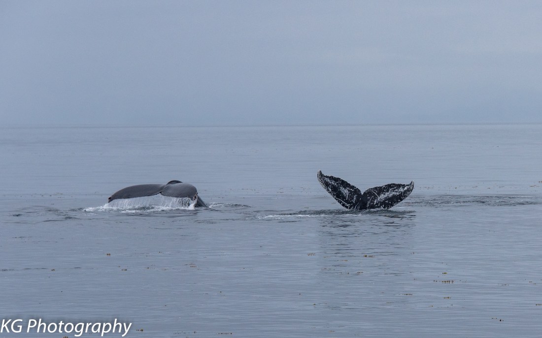
  • The highlight at Wrangell, after several hours on our way there watching humpbacks cavorting, was a trip to Anan, which is covered later.TGJ201507190213
  • At Thorne Bay we were treated to a peaceful walk through the forest to Whale House, a Haida meeting place, and a talk about Haida culture.
  • Then we had a visit to Metlakatla, an Indian community including the community center, a school and a native dance exhibition.
  • The cruise finished at Ketchikan, an interesting but commercial stopover for the big cruise ships.TGJ201507230124

Anan Bear and Wildlife Observatory

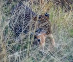
Hop in a jet boat at the dock in Wrangell, and head south along the shores of Wrangell Island and the mainland for 35 miles on an exhilarating ride to a special place. After a 30-35 minute ride (yes, that fast) one reaches the entry point to Anan. This is an area regulated by the US Forest Service, and access is limited to 60 people per day. Take a moderately difficult walk along a narrow boardwalk with 250 steps (total elevation gain is 150′) accompanied by an armed ranger – there are bears here! Eventually we reach an elevated observation deck, complete with a photographic blind down below, built over a cascading Anan Creek. This was an ancient Tlingit native fishing site. Between June and August the salmon and straining to swim up the creek, and there are bears (brown and black)and eagles galore trying to get their share! And you get very close and can take great images. If you are ever going to be in Wrangell you just have to experience this 5-6 hour excursion. http://www.wrangell.com.
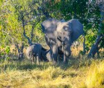
Katmai and Bears

Another wonderful adventure is a small plane trip to the Katmai Peninsula to see  bears and  glaciers. Katmai National Park and Preserve protects an active volcano landscape and 9000 years of human history, and is an important habitat for salmon and thousands of brown bears. We took a five passenger (plus pilot/guide) plane on a 45′ flight across Cook Inlet from Homer on Homer Air. The pilot landed us on the beach which was quite exciting but uneventful. We piled out and joined a second group and proceeded to check out the scene for brown bears. We soon found them – in the adjacent meadow, cavorting in the surf, digging in the sandy beach for clams and so on. We had some excitement. Two juveniles came hurtling down the beach towards the group and broke off at the last second! And we waded across a small stream to get closer to some other bears; the return trip was exciting as the tide had raised the water to hip level. While we had waders on, we got wet feet! This is an adventure well worth taking, and runs about $600 for a 5-6 hour day. Our pilot eventually reduced air pressure in the tire, we took off and he showed us closeup glaciers complete with mountain goats. http://www.homerair.com.

By the way, do you know the difference between brown bears and grizzlies??? The answer is basically nothing other than brown bears live by the water and eat fish, and grizzlies live in the mountains and eat meat.

Wildlife Rescue

While there are probably many wildlife rescue facilities in Alaska, we visited two and can highly recommend both. The Alaskan Wildlife Conservation Center (in Girdwood (45 minutes east of Anchorage) is a 200 acre site with a 1.5 mile loop which can be driven. Rescued wildlife is arranged in specific habitats, and can be fairly closely approached for pictures and general observation. The wildlife includes bears, bison, elk, deer, caribou, moose, fox, wolves, lynx, owls, eagles and more. http://www.alaskawildlife.org. The Alaska Raptor Center in Sitka, situated on 17 wooded acres adjacent to the Tongass National Forest, rehabilitates about 100-200 bird annually. They have about 25 Raptors-in-Residence including owls, eagles, hawks, falcons and kestrels; these raptors cannot be released because of permanent disabilities. One can easily do a walking tour in an hour or so, and get quite close to the wildlife. http://www.alaskaraptor.org.

Halibut Cove

My last “adventure” is less wildlife focused, but fun. In Homer, the Kachemak Bay ferry called the Danny J (29 passengers) does several trips daily. One is an afternoon visit to a bird sanctuary on Gull Island, which has 9 species of birds. Another is a dinner cruise which departs at 5 PM and sails across the bay to Halibut Cove (12 miles)and dinner at The Saltry. Halibut Cove is an isolated small community of some 75 residents with no road access. It’s population peaked in 1911 at about 1000 people, when it was a center for old herring salteries. Today it is a little jewel tucked away in Kachemak Bay State Park, and is an enclave of artists, craftsmen and commercial fishermen. There are 12 blocks of boardwalk skirting the water’s edge, with several neat little shops selling hand crafts. Sea otters, harbor seals, porpoise and eagles abound.

The Saltry is a very pleasant little restaurant situated up a steep walkway from the dock, and it has both indoor and outdoor seating. The salt air is infectious and the views of water, forests and mountains from the outdoor deck are spectacular. The fare is of course heavily focused on the sea, with oysters, mussels, octopus, scallops, halibut, wild salmon and black cod featured on the menu. The smoked black cod was indescribable. http://www.thesaltry.com.


Just a few of our most pleasant experiences in Alaska. You must see for yourself of course.


Adventures in Maui

Our favorite Hawaiian island is Maui. We have been to Maui several times, and were actually married there at Kapalua a few years ago. There are lots of activities available on the island, especially those related to the numerous beautiful sandy beaches – swimming, sunning, walking, snorkeling, surfing, windsurfing and so on. But when you are tired of all that, what else is there to do? In this blog post I am going to suggest to you several adventures that you can pursue, show you  some pictures and provide a few tips.

So here we go.

Road to Hana (all day)

Hana is a small town on the southeast coast of Maui. It is located about 42 miles from the small town of Paia, itself a neat shopping experience. The road to Hana is a windy, narrow – but paved – road which contains literally 54 bridges – mostly one way – and some 600 hairpin turns. The scenery is spectacular, with great views of the ocean, the lush rain forest and many cascading waterfalls. The whole trip will take 6-10 hours, depending on how many stops you make. There are many places with hikes, so if you want to do that, the trip will take all day. The “adventure is the journey” as they say; Hana is not the principal objective at all, although it is a very nice little place with a good beach and the only gas station around.

Here are four key tips:

  • Gas up in Hana
  • Download the app from GyPSy Guide called “Road to Hana – Maui”. The narrator will tell you where and where not to stop using GPS signals all the way past Hana; he considers five sights as “must stops”.
  • Eat at the food stands at mile 30 or at the BBQ at mile 29. The food is nourishing if not gourmet!
  • Consider driving past Hana all along the south side of the island. Parts of the road are a little rough but the scenery and changes in environment should not be missed.

Haleakala (half day)

There are two non-active volcanoes on Maui. If you want to see molten lava, go to the Big Island! However the tallest of the two on Maui is Haleakala at 10,023′ above sea level. The “crater” is actually now a valley carved by erosion. Above 7000′ this is a US National Park, and also offers many opportunities for biking (from 700′ down) and hiking. The real attraction since the late 1800’s has been to watch the sun rise over the volcanic crater. As Samuel Clemens wrote “this was the sublimest spectacle I have ever witnessed”. While sunrise is the big attraction, sunset is also a spectacle and visits during daylight hours offer fantastic views of Maui, Molokai, Lanai and the sea.

Here are four tips:

  • Register your vehicle with the Park Service ahead of time. http://www.recreation.gov. Only 140 vehicles are allowed up the mountain before 7 am.
  • Allow 2 hours from Kihei, and plan to be at the top at least 30 minutes before official sunrise.
  • Dress warmly. Temperatures can go to freezing and below, and it can be windy.
  • For the best views, stand by the railing adjacent to the Visitor Center at the end of the parking lot.

Whale Watching (two hours)

During the winter months, humpback whales arrive in Hawaii from Alaska primarily to breed. A favorite area is the waters between Maui, and Molokai and Lanai as it is relatively shallow and protected. Between December and March there are many opportunities to go whale watching out of Ma’alaea or Lahaina, usually as a two hour trip. The whales, which run to 50′ in length and 80,000 lb in weight, are fascinating to obesrve. One exciting whale activity is a competition pod, where several males try to fight over a single female for the right to mate. This is illustrated in the images below.

Here are three tips:

  • We can recommend the Pacific Whale Eco-Adventures, although one has many choices. The tours are managed by certified marine naturalists who provide lots of information about whale behavior and characteristics, and also provide underwater listening devices .
  • Try to get on early and sit in elevated seats near the front.
  • Don’t spend all your time taking pictures. Watching the mammals is great fun.

Drive beyond Wailea and Makena (two to four hours)

Another neat adventure is a drive  along the southwestern shore below Wailea and Makena, all the way to La Perouse Bay. This is really the end of the road. One can then hike for 5.5 miles along the Hoapili Trail, constructed between 1824 and 1840. This trail runs through the youngest lava field on Maui and ends up at the Hanomanioa Lighthouse. One can see very nice wildflowers, and snorkeling is quite good at the end. The contrast between unvegetated lava and the vegetated upper levels on Haleakala are quite stark.

Here are three tips:

  • If you do the walk, wear good hiking shoes and take water
  • Stop at car park at La Perouse Bay and watch the swells, snorkelers, birds and other action.
  • Take a look at the beach at Makena State Park on the way in or out.

Five Quick Suggestions

  1. Eat at Mama’s Fish House outside Paia. Expensive but the best food on Maui and and a great experience.

    IMG_1953

  2. Go to the Five Palms in Kihei for Happy Hour. Great appetizers and a great view. IMG_1918 (1)
  3. Visit  Ho’okipa Beach near Mama’s, considered the best surfing on Maui. See surfers, wind surfers and lots of sea turtles.
  4. Visit the Iao Valley just outside Wailuku. This is a stream cut valley with great displays of tropical flora and rushing waters.
  5. The beaches at Kameole in Kihei are beautiful, sandy and relatively calm for swimming, sunning, walking and snorkeling.IMG_1910


If you have any questions, please ask and we will try to help. Aloha!!


Xakanaxa Camp

The first time we saw the Okavango Delta was in May 2013 when we arrived by small airplane at Xakanaxa (ka-ka-na-ka) Camp, located in the Moremi Game Reserve north of Maun. The camp is situated on the Xakanaxa Lagoon and is surrounded by leadwood trees. There are twelve tented rooms for up to 24 guests, and the camp is considered to b a traditional safari camp with individual tents and centralized dining and relaxation.

Our experiences were generally positive, with a good assortment of game, decent food and accomodations, qualified guides and pleasant company. The primary negative about the camp is it’s location within Moremi National Park. Offroading and night driving is not allowed. In addition there are several nearby lodges, so we did encounter more vehicles than one would in a private reserve. Overall however the experience was a great introduction to the Okavango Delta.

Here are a few images from the camp.

Hamilton Greenbelt

Hamilton Greenbelt is a local park here in Lakeway, constructed on land given to the city by Jack and Myrtle Hamilton and opened in 1990. The park has several miles of trails which meander through the woods and along both Hurst and Yaupon Creeks. The park is maintained primarily by the Friends of the Parks, a volunteer organization. The Friends recently constructed a well placed and nicely constructed bird blind which we have utilized several times recently. Here are a few images taken a few days ago.


Texas Birds

I have become an avid bird photographer. Capturing birds on a digital camera is quite challenging for a number of reasons. First, it is difficult to get really close, so a substantial zoom lens is essential. I have settled on the D500 Nikon body with either a 200-500 mm lens, or a 300 mm fixed lens with a 1.4x teleconverter. Second birds are likely to move quickly, or are in flight. So one needs a fast shutter speed (I prefer 1/1000 or faster), a wide open setting like f4.0 in order to diminish the background, and an ISO setting above the minimum. I have set my camera to auto ISO and a minimum shutter speed for that purpose. I have also found that a single point focus is best; try to focus on the eyes of the bird in order to get the sharpest pictures.

Where do I take photographs? A favorite site is my own backyard, through the rear window. We have crepe myrtle trees overhanging our spa, and I prefer to capture the birds in the trees or on the spa run-over. Locally we have access to a nicely laid out and situated bird blind in the Hamilton Greenbelt in Lakeway, and this is becoming another favorite site. In addition, when we travel, I often find friends or relatives have bird feeders, and I have taken some neat shots there as well.

So here are a few of my favorite recent images.